This call is part of the umbrella of “Commercial Applications of Space-Enabled Robotics” thematic call for proposals.
This Call for Proposals invites proposals for feasibility studies and demonstration projects for services that combine the use of satellite technologies and robotics for downstream services for Smart Cities and Infrastructure.
‘Robotics’ is here defined to include physical robots, autonomous drones, machines and vehicles, and precursory solutions or those that enable these (e.g. perception and navigation systems for autonomous vehicle services, connectivity solutions to enable tele-operated robotics…).
Robotic systems could support the development of physical or “hard” infrastructure through construction site surveys, inspection, progress monitoring and support to operations. More ambitiously, autonomous construction robotics and vehicles (bulldozers, excavators, graders, pilers, pavers…) may offer solutions for preparation of land and foundations for further construction, and more sophisticated tasks.
Robotics and drones are already becoming a mainstay for physical infrastructure inspection (such as bridges, roads…) to assess safety and preservation, however there are many opportunities to extend these capabilities in terms of ability, autonomy, and the scope of sites that they can safely navigate.
Broader smart city solutions may involve robotics deployed for waste collection and street cleaning, autonomous deliveries, entertainment, social support, and tourism purposes, or other relevant domains as identified. This may be by way of autonomous shuttle services in tourist destinations, waste collection by uncrewed surface vehicles via waterways, drone deliveries, and beyond.
Value of space
Satellite Positioning can provide course to high accuracy positioning information to robots, vehicles, machines and drones operating in outdoor spaces. This can be used for navigation, geo- and timestamping of collected data, time-synchronisation of networked machines, and/or determination of speed and heading. Satellite positioning could be combined with inertial and alternative positioning techniques to support indoor-outdoor seamless localisation and marine robotics. This could manifest as navigation of autonomous vehicles, geolocation of imagery captured by drones, and more. Augmentation of GNSS can offer higher positioning accuracies for certain use-cases via solutions such as Galileo HAS (High Accuracy Service), Differential GNSS, RTK (Real-Time Kinematic), or otherwise, with the selection dependent on the service requirements.
Satellite Communications provides data, video and voice communications and may add value to applications implemented in the following service provision scenarios:
- Environments that have inadequate, unreliable, compromised, or altogether absent mobile cellular connectivity.
- Mobile services that operate across regions with varying cellular connectivity quality (good in certain areas, poor in others…) and require continuous coverage and availability.
- Services that have high security, robustness and resilience requirements may benefit from satellite communications for redundancy in compromised or unforeseen circumstances.
These may be pertinent for drone operations in rural areas, autonomous vehicles, or operations of robotics in any of the above given circumstances. New developments in satellite communications may also be exploited, such as Low-Earth Orbit (LEO) Broadband satellite constellations, to enable certain services with demanding performance or cost constraints.
Satellite Earth Observation - it is expected that satellite earth observation could support robotics solutions at the service level i.e., providing complementary or enabling datasets to support the activities of the robots. This could be through mapping data to support the navigation of the robot, or collection of datasets that complement those collected by the robot. Satellite earth observation data could refer to air quality measurements, thermal heat signatures, optical, radar, meteorology, or combinations thereof. This could manifest as use of satellites followed by drones or robotics in a “find and refine” approach, or otherwise.
Spaceflight Technology Spin-Outs - applications of robotics developed for use in space (and other astronomical objects) that also have commercial applications on Earth, i.e. Spaceflight Spin-Outs, are also considered eligible. This could relate to robotics developed for space, tele-robotic solutions and algorithms (perception, planning, control…) developed for autonomy of space robotics, or otherwise.
What we look for
We look for promising business ideas addressing topics of relevance or related areas that propose:
• attractive market opportunities, identified customer needs and customer engagement
• commercially-viable service concepts
• technically feasible solutions
• added value of space data or technology
• motivated teams with business, technical, and financial expertise
What we offer
We offer funding and support to companies, both for business case assessment and for the development of new, space-based services. Our offer includes:
• zero-equity funding*
• technical and commercial guidance
• access to our network and partners
• ESA brand credibility
*(50-80% depending on SME Status and Member State Approval)
ESA tender information
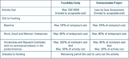
The initiative is open to the submission of proposals for Feasibility Studies and Demonstration Projects:
- Feasibility Studies - which provide the preparatory framework to identify, analyse and define new potentially sustainable services
- Demonstration Projects - dedicated to the implementation and demonstration of pre-operational services
How to Apply
1. Register your team on esa star Registration (https://esastar-emr.sso.esa.int) today. If your team is made up of more than one company or organisation, each entity will need to register.
2. Scroll down to the ‘Downloads’ section of this webpage to download the official documents. Official documents include an Activity Description (including the scope of the call, procurement approach…), an Annex (including relevant use-cases), and other supporting materials (e.g. webinar slides, if applicable)
3. Download the Activity Pitch Questionnaire template and submit your pitch as instructed in the Activity Pitch Questionnaire guidelines, through the online form.
4. ESA will evaluate your pitch. Teams whose pitches are positively evaluated will be invited to prepare an Outline Proposal and then a Full Proposal. Teams must obtain a Letter of Authorisation from their respective National Delegation before submitting a Full Proposal. Contact details of all National Delegates can be found here: National Delegation(s).
Authorisation of funding
This opportunity is open to companies that intend to develop space-enabled services and products related, but not restricted, to the topics of relevance outlined above. To be eligible for funding, your team must be based in one of the following countries: Austria, Belgium, Czech Republic, Denmark, Estonia, Finland, France, Germany, Hungary, Ireland, Italy, Lithuania, Luxembourg, Netherlands, Norway, Poland, Portugal, Romania, Slovenia, Sweden, Switzerland and United Kingdom. Teams can involve non-European entities, but their contribution to the activity cannot be funded by ESA. Authorisation of Funding letters from the corresponding National Delegations are required as part of the application.