ESA title

Trees tell their own story to satellites

Communications via satellite are changing the way the forest industry harvests trees. A new approach being tested by ESA combines satcoms and cellular services to relay important information almost immediately so that fewer trees are used to produce more timber.

Irish company Treemetrics, in cooperation with ESA, is developing a new system via the ARTES 3-4 SATMODO project. The SATMODO system will be used to provide a data back-haul and communications platform for harvesting vehicles, whereby the harvesting work flow can be managed in near realtime to deliver a fully integrated management system to customers.

Managers can now send instructions directly to computers in the vehicles via satellite, instructing operators how to cut to make the best use of the trees.
All trees are not created equal. Some are more suited to be used to make pulp, while others are better suited as 'sawlogs'. for cutting into timber in a sawmill, making them more valuable.

Such trees are greater in diameter, straighter andTree scan classification have fewer knots. Cutting down valuable sawlog trees for producing pulp is a waste and reduces the crop's worth.
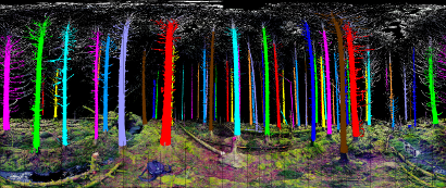
Treemetrics had already designed a new way to assess the value of a timber crop before harvest using 3D laser scanners to measure the shape, size and straightness of standing trees. The software produces .a cut instruction. file, based on the customer.s request, which tells the machine and its operator how to harvest the forest.

Until now, managers had to give harvesters the data they needed to cut trees via email, by phone, or face to face. Emailed information had to be manually entered into a control computer on the vehicle and uploaded every time the machine required a new instruction file.

Officials Meeting at Project Launch EventNow, thanks to satcoms, ESA provides the missing link in the chain: SATMODO's two-way realtime or near-realtime connection with the harvesting machines.
By gathering information on what the actual timber yield is per hectare and sending back this information through SATMODO, the actual harvest can be determined almost in real time and amended on the spot, rather than waiting until after the entire forest has been cut.

SATMODO consists of a hybrid satellite/terrestrial wireless device installed in the vehicle, transmitting data in real time via the new Inmarsat IsatM2M service supporting two-way burst messaging over worldwide satellite coverage (except the poles), using L-band remote terminals with highly compact antennae.
SATMODO also provides a communications 'safety net' for harvesters who frequently work in remote locations. It keeps workers in constant contact in areas where land-based mobile networks simply won't work.

SATMODO WorkflowTo test the SATMODO system, the hybrid device will be installed in 20 harvesting vehicles, allowing individual machines or groups of machines to be monitored. Harvesting workflow will be managed in near-realtime, creating a fully integrated management system.

Based in Cork, Ireland and endorsed by Ireland's Minister for Research and Innovation, Mr. Seán Sherlock, Treemetrics has spent years developing measurement and analytics technology to replace traditional forestry methods.
The company approached ESA through its Integrated Applications programme to help develop their technology further through the use of satellites.

 "ESA with its innovative integrated application platform is very pleased to support a great idea coming from this young entrepreneurship," said Amnon Ginati, the Head of the Integrated and Telecommunications-Related Applications Department at ESA.

"We are also very pleased with the endorsement that it is receiving both at a political level and from Enterprise Ireland."
 

Teaser paragraph

Communications via satellite are changing the way the forest industry harvests trees. A new approach being tested by ESA combines satcoms and cellular services to relay important information almost immediately so that fewer trees are used to produce more timber.

Ambassador Platform for the Dual-Use of Space-based Services (APDUSS) - Portal is now online

The Ambassador Platform for Dual-Use Space-based Services (APDUSS) will be a gateway for stakeholders who are interested in potential services which fulfil the various needs of Defence and Civilian Users.

Hosted by the Office of the Advisor for Aerospace Activities Italian Ministry of Defence in Rome, it contains news stories and announcements of events, provides an archive of recent and on-going IAP initiatives and makes available useful documents. Community portals are intended to be a communication platform and promotional tool for IAP activities (studies, projects, opportunities, etc.) related to the subject.

Exemplary focus areas include:

Telemedicine in prisons and refugee centres:

Space satellites can provide a quick link between patients and doctors. They can be used to ensure medical treatments even during emergency situations, in remote geographical areas and in prisons.

Vessel Traffic Monitoring:

Through the combined use of the information already available, stakeholders such as harbour authorities and coastguards will get a more complete picture of maritime traffic moving along shipping lanes and between ports right around the globe. Satellite-AIS (Automatic Identification System) together with coastal AIS and LRIT (Long Range Identification and Tracking of ships) will become a complementary source of ship information usable by the user communities.

Please click here to visit the APDUSS Portal. It offers public and private interactive services, such as discussion and document exchange tools.

By registering to this portal, one can download documents such as reports and presentations, as well as participate in discussions with other members. Moreover, registered users are able to post public and private articles.

Teaser paragraph

The Ambassador Platform for the Dual-Use of Space-based Services (APDUSS) region will be a gateway for stakeholders who are interested in potential services which fulfil the various needs of Defence and Civilian Users. By registering on this portal, one can download documents such as reports and presentations, as well as participate in discussions with other members.

Surveillance and Control of Land Borders from Space

The control and surveillance of borders is an essential function of any state which if done efficiently, can lead to a reduction in cross-border crime and illegal migration.

For the last year Astrium, in collaboration with the Greek Border Guard and the Greek Institute for Security Studies, has been studying the feasibility of using space assets to support the surveillance and control of land borders.

Greece controls the part of the external land border of the European Union over which the majority of illegal migrants enter Europe. It also faces challenges with cross-border criminality, particularly on the Greek / Albanian border.

In the IAP feasibility study just completed, it was possible to confirm the usefulness of satellite communications, tracking, and Earth observation techniques as contributors to the control of the Greek border. This included the provision of services to the Border Guards during a short proof of concept demonstration which was conducted during the summer of 2011 on the Greek / Albanian border.

During this proof of concept demonstration techniques for tracking patrols and distributing the information to commanders, the use of satellite communications, and Earth observation techniques were demonstrated. The Earth observation products included reference mapping, hot spot monitoring, and techniques to develop permeability mapping for the border area. These products were distributed to the field locations over satellite communications links.
The feasibility project has now come to an end and Astrium intends to take the concept forward with a follow-on demonstration project in 2012.

Teaser paragraph

The control and surveillance of borders is an essential function of any state which if done efficiently, can lead to a reduction in cross-border crime and illegal migration.

Challenges for Intermodal Freight Transport through Liverpool Port targeted

The optimisation of freight transport through ports holds interesting challenges for solutions utilising the added value of satellites. Addressing the challenges of freight operators such as the reduction of delays, optimisation of traffic management, and exchange of information have been priority topics at a workshop held in Liverpool on December 15th, 2011, as part of a recently started ESA IAP activity addressing the subject.

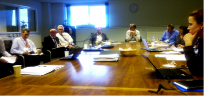
The workshop was attended by representatives of the port community of Liverpool including Mersey Maritime, The Mersey Partnership, Peel Ports, JMD Haulage, and Atlantic Container Lines, and representatives from the project teams and ESA.

Liverpool Workshop Photo

Following the award of two parallel projects for this activity, representatives from both teams, one led by AIMES and the other by GMV, were given the opportunity to directly discuss the top priority needs and challenges with the users. These needs and challenges will serve as input for specification of an integrated solution and associated services supporting the optimisation of freight transport through ports and meeting the priorities of the port community.

In support of a solution which can be deployed in more international ports, both project teams will also engage with other users and stakeholders in the near future. Furthermore, The Mersey Partnership, Mersey Maritime and users present at the meeting will further engage with users and stakeholders in the Liverpool area and their international partners.

The workshop has provided both teams with an excellent start to identify innovative and sustainable services addressing freight transport through ports and utilising space assets to realise this.

The team led by GMV (ES) further includes Teirlog (ES), BAE (UK), Brimatech (AU) and TeleConsult (AU). The consortium led by AIMES (UK) further consists of Containerport (UK), Avanti (UK), DMCii (UK) and ISL (D).

Teaser paragraph

The optimisation of freight transport through ports holds interesting challenges for solutions utilising the added value of satellites. Addressing the challenges of freight operators such as the reduction of delays, optimisation of traffic management, and exchange of information have been priority topics at a workshop held in Liverpool on December 15th, 2011, as part of a recently started ESA IAP activity addressing the subject.

eHSA programme kicks-off with study on Governance

The European Space Agency (ESA) has launched the first of four feasibility studies under the Satellite-Enhanced Telemedicine and eHealth for Sub-Saharan Africa (eHSA) programme, eHealth governance. Funding for this study has been provided by the Infrastructure Trust Fund (ITF - the instrument of the wider European and African Union.s Partnership on Infrastructure) and the Government of Luxembourg through ESA and the Luxembourg Agency for Development Cooperation (LuxDev).

The dire need for a programme such as eHSA can be exemplified by the massive discrepancy between the disease burden, health workforce, and health expenditures in Sub-Saharan Africa (SSA). Presently, the region has 25% of the world.s communicable disease burden, but only 3% of the world.s health workforce and 1% of global expenditure on healthcare. The deficits in funding and health workers challenge the provision of even basic healthcare services to a population exceeding 840 million people, thereby exacerbating the situation. The success of any approach focusing on solving these issues will depend on its capability to ensure a strong African ownership of resources, to support solutions to critical health aspects and to generate positive social and economic benefits for the population. eHealth systems are increasingly seen as a way to solve these threats, particularly in remote areas.

The first challenge to be faced by the eHSA programme is how to provide a firm foundation to provide eHealth services. A careful analysis of sub-Saharan healthcare governance is necessary to identify relevant healthcare processes, stakeholders, priorities, political and financial issues and technical complexities. Only with this perspective, it will be possible to build up compatible governance models supporting the provision of eHealth services while enabling positive benefits. Governance has to be seen as the driver of the remaining actions of the eHSA programme. Proper governance is mandatory so that the sub-Saharan community can adopt and use eHealth services, guarantee their scalability and ensure sustainability. Therefore, the governance study is seen as an essential step to ensure the success of the entire eHSA programme.

This study will be conducted by a consortium of companies led by Logica PLC,  Alter Santé, ESCEM, and UNISA. It will count on the support of relevant African or African-based health organisations such as RAFT (Réseau en Afrique Francophone pour la Télémédecine), AMREF (African Medical and Research Foundation), Merlin, Le Kinkeliba, and CIDMEF (Conférence Internationale des Doyens et des Facultés de Médecine d'Expression Française).

Teaser paragraph

ESA has launched the first of four feasibility studies under the Satellite-Enhanced Telemedicine and eHealth for Sub-Saharan Africa (eHSA) programme, eHealth governance. Proper governance is mandatory so that the sub-Saharan community can adopt and use eHealth services, guarantee their scalability and ensure sustainability.

Demo project combines satellite and terrestrial data for efficient vessel tracking

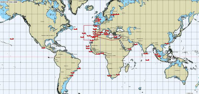
Tracking of Blue Ships (worldwide coverage)Selected offshore vessels within EU waters and beyond are now in sight of EU customs officials as an ESA demonstration project, in support to the European Maritime Safety Agency’s Blue Belt pilot project, gets fully underway.

The ESA IAP Demonstration Project (ARTES element 20) led by the prime contractor CLS (Collecte Localisation Satellites), with exactEarth Europe and KSAT as sub-contractors, has been delivering SAT-AIS data to EMSA since 20 October 13:00 UTC.

The satellite data will be carefully assessed to ensure it meets end-user and stakeholder requirements. It will also determine whether SAT-AIS services offer added value to the terrestrial AIS data for this type of ship tracking based service.

EMSA initiated the Blue Belt pilot project to promote short sea shipping and assist  EU customs authorities by providing them with additional information about ships, their journey and their cargoes within the EU. A total of 250 voluntary vessels or “blue ships” are being tracked. Customs authorities of EU Member States receive a timely notification report before the arrival of a blue ship to an EU port.

The ESA demonstration project provides a service based on satellite-based AIS data complementing the terrestrial data collected by EMSA. This service detects offshore vessels equipped with AIS tracking devices which are impossible to detect by shore-based systems alone. Knowing the actual vessel journey beyond the coastal region is important to Custom authorities. This can only be achieved by using satellite AIS data.

Teaser paragraph

Selected offshore vessels within EU waters and beyond are now in sight of EU customs officials as an ESA demonstration project, in support to the European Maritime Safety Agency’s Blue Belt pilot project, gets fully underway.

Bird Avoidance Services - Participate in Online Survey

Bird Strike LogoBird strikes remain an issue for civil aviation and the “Bird Strikes Risk Reduction for Civil Aviation” IAP feasibility study is currently seeking feedback from the aviation community, and from airports in particular, on a new set of proposed services that might help reduce the risk of bird strikes.

The study is in the process of identifying new satellite-based services that should help to reduce the risk of bird strikes and that could be implemented in the near-term.

To capture user requirements, test demand for those new services, and explore their commercial viability an online survey has been launched, which takes 5-10 minutes to complete, and is open to all aviation stakeholders.

We encourage all stakeholders with an interest in bird strike reduction to complete the survey. Your answers will help to understand the needs of the aviation market and the level of demand for these new services.

Take part in the survey now.

For more details on the survey, please visit Helios Ltd. website, prime contractor of the study or ESA IAP Programme (iap@esa.int). Survey closes 31st of January 2012

Teaser paragraph

Bird strikes remain an issue for civil aviation and the “Bird Strikes Risk Reduction for Civil Aviation” IAP feasibility study is currently seeking feedback from the aviation community, and from airports in particular, on a new set of proposed services that might help reduce the risk of bird strikes.

Ambassador Platform for Dual-Use Space-based Services (APDUSS)

APDUSS LogoIAP is pleased to announce the start-up of the Ambassador Platform for Dual-Use Space-based Services (APDUSS). The Ambassador Platform will be managed by the Office of the Advisor for Aerospace Activities in the Italian Ministry of Defence. The main objective will be to assist the IAP programme in spreading awareness for potential stakeholders in ESA’s IAP programme in the field of dual-use.
The APDUSS platform will address simultaneously the needs of Civilian and Defence users. Integrated space-based services will be explored for fulfilling the goal of dual use, for example, in support of telemedicine and marine safety and security.
The inauguration workshop for the APDUSS platform will take place on 1st February 2012 in the Centre for High Defence Studies (CASD), in Rome.

For more details, please contact:

Massimo Cavaliere
m.cavaliere@cira.it
Tel: 0039 348 736 1322

A dedicated community portal will soon be launched to support the activity of the APDUSS platform.

Teaser paragraph

IAP is pleased to announce the start-up of the Ambassador Platform for Dual-Use Space-based Services (APDUSS). The Ambassador Platform will be managed by the Office of the Advisor for Aerospace Activities in the Italian Ministry of Defence.

Water Use Efficiency for Vineyards

Limited water resource availability and efficient water management are major global challenges facing policymakers worldwide. In collaboration with the University of KwaZulu-Natal, the Dutch company WaterWatch has demonstrated a pre-operational service aimed at tackling these challenges. The GrapeLook project was co-funded by the Department of Agriculture of Western Cape in South Africa and by the ESA Integrated Applications Promotion programme.

Western Cape Satellite ImageIn South Africa, water is a critical resource and there is strong competition between the urban, industrial and agriculture sectors. The National Water Act (1998) states that water should be used efficiently and has to be reserved for basic human needs and for protecting aquatic eco-systems first, with agriculture having a lesser priority. However, agriculture remains of high economic importance as it contributes to export, employment and livelihood. The challenge is to increase agricultural production while reducing water consumption.

Water Use EquationOne of the major sectors in the Western Cape Province of South Africa is the table and wine grape industry. Water productivity or water use efficiency (WUE), defined as crop production divided by the total water consumption, is a vital parameter to assess agricultural performance. To optimise the water use efficiency, one needs information on the crop production and the crop water consumption. The physical process behind crop water consumption is the process of actual evapotranspiration (ETact).

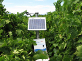
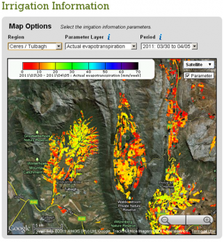
Grapelook Satcom TerminalIt is well known that satellite Earth observation can deliver regular maps on physical properties of vegetation. In the GrapeLook project, space based remote sensing algorithms are used to monitor actual evapotranspiration, biomass production and water use efficiency as well, and this is a breakthrough.  The engine of the system relies on a complex modelling scheme which ingests Earth observation data and in situ measurements (left picture). In-situ soil moisture measurements are transferred in real-time to the processing centre thanks to a satellite communication link. 

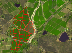
Grapelook Satnav Farm MappingOnce the product is generated by the processing centre, the maps are displayed to the users (farmers and authorities in charge of water management) through a Google Maps based website www.GrapeLook.co.za. A group of demonstration farmers also received forecasts on soil moisture and irrigation water requirements for their farms. The farms of the demonstration farmers have been accurately geo-referenced thanks to GPS surveys (right picture).

Participating grape farmers received training on how to use the information provided by the pre-operational service. During the 2010-2011 grape growing season, they have regularly connected to the website to check the status of their own farms. Their feedback can be summarized as follows.

  • GrapeLook is useful to monitor crop water stress, crop growth, and to identify irrigation system malfunctions;
  • GrapeLook supports more efficient farm management practices;
  • On the medium term, GrapeLook will help reducing labour and input costs, increasing products quality/yield and improving water use efficiency.

The demonstration project also convinced the Department of Agriculture: Western Cape that GrapeLook is a very cost effective tool for improving water use efficiency.

Grapelook Service InterfaceThe project was successfully completed in October 2011. It proved that the system concept was mature although a number of improvements are needed for GrapeLook to become a fully operational service in the coming years.

But most important the project showed that the target end-users were supportive of such a service, although very innovative. It will take a few years to strengthen trust and awareness with these user communities. The South-African authorities are aware of this, and are willing to support the prolongation of a freely available GrapeLook service for another season.

Community reference
Teaser paragraph

Limited water resource availability and efficient water management are major global challenges facing policymakers worldwide. In collaboration with the University of KwaZulu-Natal, the Dutch company WaterWatch has demonstrated a pre-operational service aimed at tackling these challenges. The GrapeLook project was co-funded by the Department of Agriculture of Western Cape, South Africa and by the ESA's IAP programme.