ESA title

Video: SADA helps demining in Bosnia

Landmines and explosives continue to disrupt lives and kill long after conflict situations have ended. This is the case in tens of countries around the world. The Mine Action community attempts to reduce the number of victims and return land to people for agriculture and everyday life. Together with the user community and space industry ESA is developing new services that meet actual needs in many domains by integrating different satellite applications.

This video showcases the example of Hadzici, an area near Sarajevo, Bosnia-Herzegovina

To support demining, new services aim to assist the setting of mine action priorities and risk assessment thus also improving demining efficiency. By complementing existing mine action techniques with imagery from Earth Observation and with Satellite Navigation tools, resources can be allocated according to demand and priorities. ESA's Integrated Applications Promotion (IAP) provides the framework for combining existing techniques and space-based systems to formulate a new approach to demining.

Teaser paragraph

Landmines and explosives continue to disrupt lives and kill long after conflict situations have ended. The Mine Action community attempts to reduce the number of victims and return land to people for agriculture and everyday life. Together with the user community and space industry, ESA is developing new services that meet actual needs in many domains by integrating space-based systems.

IAP activities for Africa showcased at IAC

he Integrated Applications Promotion programme has recently showcased a number of its activities that contribute to the development of the African continent, at the 62nd edition of the International Astronautical Congress (IAC). The associated papers and presentations are now available for download.

The IAC is the world's premier annual global space conference, and was held in Cape Town from 3-7 October, with the theme "African Astronaissance". It was directly preceded by the 21st UN/IAF Workshop on .Space for Human and Environmental Security. from 30 September to 2 October.

21st UN/IAF Workshop on Space for Human and Environmental Security

Rally2ReadThis workshop covered four sessions followed by lively plenary discussions: Space and Climate Change, Space for Food and Water, Space for Health and Space for Environment.

The IAP programme participated with the following presentations with topics ranging from e-health and epidemiology via demining to improving literacy in rural areas.


UN/IAF Workshop Presentations 

Presentation


Author


Keynote Address - Space and Sustainable Development in Applications

Prof. Amnon Ginati

ESA/IAA/IAF

ESA IAP and Space for Health

Prof. Amnon Ginati

ESA/IAA/IAF

Building E-health Services for Sub-Saharian Region in Africa

Prof. Alexander Horsch

Institute for Medical Statistics (IMSE), Germany

Space and Epidemiology


Dr. Michiel Kruijff

ESA

Space for Education, and its Relevance to Children Health (Rally2Read initiative)


Ms. Pam Richardson, Ms. Iris Francis

South Africa

Space for Humanitarian Demining


Dr. Michiel Kruijff

ESA


62nd Edition of the International Astronautical Congress

At the IAC, user and IAP representatives highlighted a number of activities that take place in or have relevance for the African continent.

In the Smallsat session (B4.4), the development of a Satellite-based AIS (Automated Identification System) for vessel tracking was reported that can help e.g. in the identification of hijacked ships.

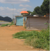
Integrated application end-to-end solutions were presented in session B5.1. Ms. Annemarie Klaasse from the Grapelook project explained how satellites can help to reduce the water consumption for vineyard irrigation in South Africa. A pipeline, as indicated by the red marker pole, runs beneath makeshift housing (SASOL Gas, PIMSIS project).Mr. Neo Modise, a user representative from SASOL Gas in Johannesburg, clearly illustrated the need for improved and more efficient monitoring of pipelines integrity and related threats (PIMSIS project). Mr. Marco Giancarli from the S2BAS project described how satellite navigation, Earth Observation and satellite communication can be used to improve the safety for planes landing at small, underequipped and remote airports. Dr. Michiel Kruijff, technical officer of the VECMAP feasibility study, reported the successful development of a system for disease vector mapping (moquitoes in particular) that is now moving towards pre-operational service demonstration in twelve countries including Benin. Other IAP activities presented covered veterinary epidemiology in Senegal (PREDICT project) and demining assistance service development (SADA project) in which mine action users from e.g. Sudan and Egypt are involved.

Rally2ReadIn the session for Integrated Application Tools (B5.2), Prof. Dr. Alexander Horsch (Institute for Medical Statistics) stressed the importance of e-Health to save lives and detailed IAP.s newly started programme e-Health for 48 countries of Sub-Saharan Africa.  Finally, the presentation of the IRISS project showed how TITAN, a compact integrated system can be fitted retroactively in older trains to make more efficient and effective their tracking and operations and maintenance management.

IAC Abstracts & Presentations

Paper


Presentation


Author


IAC-11-B4.4.2

European Satellite AIS under Joint EMSA/ESA Integrated Applications Programme

C. Tobehn, A. Schönenberg, R. Rinaldo, A. Ginesi, A. Ginati, L. Sciberras, L. Bal

IAC-11-B5.1.1

Grapelook: Space based services to improve water use efficiency of vineyards in South Africa

A. Klaasse, C. Jarmain, A. Roux, O. Becu, A. Ginati

IAC-11.B5.1.3

PREDICT, Prevention and Response to Epidemics with Demonstration of Information and Communication Technologies

C. Bastón Canosa, A. Ginati, O. Tournebize, S. Bastier, Y. Lapeyre, A. Berthier, E. Ducheyne,

B. Sall

IAC-11-B5.1.7

Space Assets for Pipeline Integrity Management (PIMS)

M. Kruijff , A. Bos, R. Bos, N. Modise, A. Mieremet , A. Ginati

IAC-11-B5.1.9

Space Assets for Demining Assistance

M. Kruijff, D. Eriksson, T. Bouvet, A. Griffiths, M. Craig, H. Sahli, F. Valcarce González-Rosón, P. Willekens, A. Ginati

IAC-11-B5.1.10

Mapping habitats for vectors of infectious disease: VECMAP

M. Kruijff, G. Hendrickx, W. Wint, A. Ginati

IAC-11-B5.1.12

Space Services Benefits in Aviation System (S2BAS)

M. Giancarli, A. Monteleone, F. Sautto, O. Becu,  A.Ginati

IAC-11.B5.2.6

Satellite-enhanced telemedicine and ehealth for Sub-Saharan Africa: a development opportunity

G. Martín-de-Mercado, A. Horsch, G. Parentela, P. Mancini, A. Ginati

IAC-11-B5.2.7

Intelligent Railways via Integrated Satellite Services (IRISS)

M. Kruijff, M. Dumville, Mr. M. Hutchinson, A. Ginati


Teaser paragraph

The Integrated Applications Promotion programme has recently showcased a number of its activities that contribute to the development of the African continent, at the 62nd edition of the International Astronautical Congress (IAC) and the 21st UN/IAF Workshop on Space for Human and Environmental Security. The associated papers and presentations are now available for download.

Vacany Notice: Internal Fellowship in Integrated Application Development Activities (IAP)

The Applications Business Office of the Integrated Applications Promotion (IAP) department in the Directorate of Telecommunications and Integrated Applications wishes to announce a vacancy for an Internal Research Fellowship with a starting date of 1st January 2012. The Research Fellowship is available for two years, and will be based at Harwell in the UK.

About the European Space Agency and the Integrated Applications Promotion (IAP) programme

The European Space Agency is Europe’s gateway to space. Its mission is to shape the development of Europe’s space capability and ensure that investment in space continues to deliver ever more benefits to all the citizens of Europe.

The objective of ESA’s Integrated Applications Promotion (IAP) programme is the development of operational services for a wide range of users through the combination of different systems. By using and integrating different space assets (Satellite Communication, Satellite Navigation, Earth Observation, Manned Space Technologies), improved or new services on a regional, national or European scale can be created. Intrinsic to these new applications is the added value of space and the long-term sustainability of the resulting services. The programme thereby responds to user needs in areas such as health, safety, energy, transport and development.

The main aim of the IAP programme is to identify user and stakeholder communities and to identify, foster and organise user demand (Capacity Building in the Integrated Space Applications domain). This also includes the creation of partnerships with suitable user communities. The Research Fellow will be responsible for stimulating one or more new applications that utilise and integrate different space assets, resulting in new or improved services. In order to carry out his/her function the Research Fellow will work within a dedicated team.

Duties

The Research Fellow will report to the Head of the Applications Business Office and will be responsible for research activities within any of the disciplines of the Integrated Applications Promotion (IAP) programme

The Research Fellow will have as his/her main responsibilities:

  • Research in a chosen discipline to assist in the establishment of one or more IAP projects.
  • Preparation of new Regional or Thematic application fields.
  • Supporting identification of User Communities and their Needs.
  • Identification of appropriate Space Capabilities (Satellite Navigation, Telecommunications and Earth Observation).
  • Identification of technological gaps, in order to propose future missions and systems.
  • Supporting preparation of promotional materials and workshops to federate user communities.

Some examples of ongoing IAP initiatives that the Research Fellow might support include activities on the Arctic; Offshore Renewable Energy; Under-developed Countries; Machine to Machine (M2M) or Internet of Things (IOT); Insurance / Reinsurance; Maritime Safety and Security; Carbon Trading; and Tourism.

Qualifications

Applicants must have recently attained their doctorate or be close to successfully completing such studies in space science, space applications or techniques, or other fields closely connected to space activities in one or more of the target domains for IAP initiatives noted above. This might for instance include Geographical Information Systems, the commercialisation of space technology, or business, commerce and economic analysis.

Applicants for this post should preferably also have significant and sound experience in at least one of the space technologies covered by this position (i.e. in the Telecommunications, Satellite Navigation and Earth Observation sectors), ideally with a specific emphasis on applications.

Other qualifications required by the candidate include:

  • Strong analytical, strategic and problem solving skills.
  • Creativity and an innovative attitude.
  • Good communication, interpersonal and presentation skills.
  • Self-motivated and disciplined, with the ability to plan and manage own work.
  • Ability to cope under pressure and ensure deadlines are met.
  • Strong attention to detail.
  • Good organisation skills.
  • Results orientated, with a strong drive to deliver.
  • Good team player, able to work in a close-knit team and also in an international environment.
  • Proficient in all MS Office packages.

The working languages of the Agency are English and French. A good knowledge of English is required for this post.

How to Apply

Please apply via the applicant webpage on the ESA web-site:

http://www.esa.int/SPECIALS/Careers_at_ESA/SEMICLRTJRG_0.html

Please mark your application with “IAP Applications Business Office” in the title, as well as providing a detailed description of your proposed area of research. This must be within one of the specified IAP themes. Applications should be submitted under the “Internal Fellowship Programme”.

Please send your applications for this post by 7th December 2011. Later applications will only be considered if no suitable candidate has been selected.

Teaser paragraph

The Applications Business Office of the Integrated Applications Promotion (IAP) department in the Directorate of Telecommunications and Integrated Applications wishes to announce a vacancy for an Internal Research Fellowship with a starting date of 1st January 2012.

ESPI/ESA Report on "€žSpace Applications for Civil Protection"€ available online

The report, entitled Space Applications for Civil Protection provides a roadmap for Civil Protection with particular interest in SatCom and has been published as a contribution to the Polish EU Council Presidency 2011. It intends to highlight a potential way forward in improving the overall operational capabilities of European Civil Protection agencies through the use of satellite-based services. It represents a joint effort of the European Space Policy Institute (ESPI), the IAP Ambassador Platform for the CEE region (APCEE), and ESA.

The report reflects the main issues which were discussed during a workshop organized by ESPI, together with the Austrian Federal Ministry of the Interior (BM.I), the Austrian Aeronautics and Space Agency, and ESA on 5/6 May 2011. It aims at identifying user needs and gaps in existing services as well as the most appropriate way forward for generating space-based, user-driven activities creating direct benefit to the European Civil Protection community. The report underlines that dedicated efforts are needed to enhance interoperability, availability, cost effectiveness, and best practice of the Civil Protection community based on satellite-based services. For the time being, no institutional European mechanism has been established to allow the European disaster management community to have efficient and simple access to space-based systems. In addition specific needs of the disaster management community have not been clearly articulated to enable the development of appropriate resources and services by the space industry.

The study is structured into main parts. The first part provides an overview of the current status of Civil Protection (CP) in Europe, including the drawbacks of the current systems and ESA's past user-driven activities to overcome these shortcomings. The second part delineates the national strategies and perspectives of CP agencies of selected European States with the focus on satellite-based applications that were presented during the workshop. Based on the summary of the roundtable discussions, current shortcomings regarding the utilization of satellite-based services and the requirements of the CP community are identified. The third part of the study analyses the current international and European regulatory framework based on the needs and requirements of the Civil Protection community. It highlights relevant aspects that would guarantee legal certainty and an effective mechanism to respond to disasters in a timely and flexible manner. Moreover it reviews recent developments at EU level with respect to the review of the EU Civil Protection legislation. Finally, recommendations to improve the overall operational effectiveness of CP users through the use of space-based systems SatCom are provided and concrete measures are outlined.

For further information please contact:

Erich Klock
Manager of the IAP Ambassador Platform for the CEE region
European Space Policy Institute (ESPI)
Email: erich.klock@espi.or.at

Teaser paragraph

The report, entitled "Space Applications for Civil Protection" provides a roadmap for Civil Protection with particular interest in SatCom and has been published as a contribution to the Polish EU Council Presidency 2011. It intends to highlight a potential way forward in improving the overall operational capabilities of European Civil Protection agencies through the use of satellite-based services.

SADA Mine Action studies about to start Proofs of Concept

IAP's Space Assets for Demining Assistance (SADA) projects investigate how space-enabled services can support Land Release in Mine Action. Three parallel studies have been implemented that have formulated conceptual services that will next be demonstrated in field settings. To ensure the intended SADA services are directly relevant to the Mine Action community, the users. involvement has been fundamental:


Photo 1: Demining demonstration during SADA field trip to Tajikistan. Credit: FSD/SADA. Photo 2: The SADA teams at the IMSMA/SADA interface development workshop. Credit: GICHD. Map 1: Geographical distribution of Mine Action user representatives so far involved in the SADA needs analysis.


In particular, the Geneva International Centre for Humanitarian Demining (GICHD) plays an important role as ESA.s external advisor. The GICHD strives to provide capacity development support, undertake applied research, and develop standards, aimed at increasing the performance and professionalism of mine action. In an interview with ESA, GICHD representative Dr. Daniel Eriksson shares his views on the SADA project.

GICHD has supported the project definition, participates in project reviews, and has hosted a SADA discussion with the consortia and user community during the 14th International Meeting of National Mine Action Programme Directors and UN Advisors (March 2011). In August 2011, GICHD organized a training workshop for the SADA consortia in order to allow them to develop effective interfaces between SADA services and IMSMA, GICHD.s Information Management System for Mine Action in use by almost all Mine Action programs today.

In addition, a large number of operational Mine Action entities and user representatives have so far been involved in the SADA projects, e.g. through workshops and user surveys. One of the users, the Swiss Foundation for Demining (FSD), a relatively small but representative Swiss-based NGO, has provided a shared user needs baseline to the SADA participants from the field operator perspective, and has hosted interested SADA participants for a field visit to one of their demining sites in Tajikistan.

Now, in October 2011, the three SADA consortia will each initiate one or more Proofs of Concept to demonstrate their solutions to Mine Action users. Mine Action users in, amongst others, Bosnia i Herzegovina, Afghanistan and Chile will host these Proofs of Concept in order to:

  • Iterate the service & system design
  • Validate the foreseen performance against the user requirements
  • Decide whether to support the development of a pre-operational service in a possible follow-up (Demo Project).
Teaser paragraph

IAP's three parallel studies into the use of Space Assets for Demining Assistance (SADA) are about to start initial field demonstrations of potential service elements. These Proofs of Concept are performed with the involvement of various Mine Action operators.

Getting the picture via satellite

As cinema owners worldwide begin to embrace new digital technologies via satellite, audiences are being given more ways to enjoy an evening at the movies.

The emergence of new digital technologies and standards has paved the way for innovative and cost effective solutions for cinemas. The transition from analogue to digital has been recently boosted by innovative formats (e.g. 3D movies) and by the increasing demand for live and interactive events (e.g. sport, operas, virtual theatres, seminars) hosted in cinema theatres.

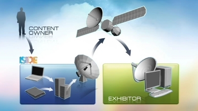
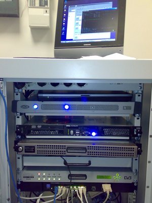
Through the ESA ARTES Applications programme, a secure, cost effective system enabling cinemas owners to receive movies via satellite has been developed by a consortium composed of Italian companies (Microcinema, OpenSky, Skylogic, Digital Pictures, with the support of the Business Incubator Centre BIC Lazio in Rome). Thanks to this new system known as ISIDE (Innovative Satellite Interactive Digital Entertainment), cinema operators can now browse a content catalogue of hundreds of movies, and perform the orders on-line.

But it is not only traditional movies that are being shown in today.s cinema theatres. The evolution of digital and electronic cinema has brought new forms of entertainment with it, such as movies in 3D, interactive events and virtual theatre. Through the ISIDE network, a virtual theatre event was set up and successfully demonstrated, putting together in the same virtual stage two groups of actors, one located in Rome and one in Burkina Faso (West Africa).

However, satellite capacity is a very valuable and expensive resource. In order to make the distribution via satellite effective, the same content has to reach a sufficient number of cinemas. This is especially true for top quality digital standards such as DCI (Digital Cinema Initiatives), which involves high volume of data (one single movie can exceed 200 GBytes) and high transmission rates (up to 100Mbit/s). ISIDE brings the convenience of satellite technology within reach. When multiple locations in the network download a film, the costs of satellite capacity are shared among them.

Today, Microcinema, with more than 200 cinemas connected in a bidirectional satellite VPN, has become a leader in Italy for providing film, audovisual content, live opera from Italian and European theatres as well as cultural events such as music concerts, theatre performances and premieres. Microcinema distributes two or three live events per month, plus one or two flims per week.

OpenSky mainly provides for the delivery of DCI movies from major Hollywood Studios and the distribution of live events to more than 600 cinemas spread throughout Italy, France, Germany and Spain. Most of the cinemas are equipped with the state-of-the-art professional receivers and projectors.

.The opportunity provided by the ISIDE project has been very instrumental to Microcinema, as it occurred when the company started to approach the market proposing possible satellite services,. explains Silvana Molino from Microcinema. .The successful pilot phase of the system, developed and tuned in 2010 during the ISIDE project, proved to be fundamental for cinemas owners. persuasion..

According to Walter Munarini from OpenSky: "The ISIDE project was fundamental to Opensky to implement the first European network of digital cinema capable of receiving satellite services like the live events and movies via satellite, as well as its evolution to live 3D events."

For more information visit the project web page.

Teaser paragraph

As cinema owners worldwide begin to embrace new digital technologies via satellite, audiences are being given more ways to enjoy an evening at the movies.

Stargazing - Rail Technology Magazine looks into the impact of space technology for the rail industry

(First published in Rail Technology Magazine, Issue April/May 2011)

Railways and satellites are not obvious companions, but an increasing number of rail companies across Europe are starting to explore the commercial and operational benefits of integrating space technologies into their systems.

In the latest issue of the Rail Technology Magazine, Alan Brunstrom of the European Space Agency explains the impact that space technology could have on the rail industry in signaling and telecoms.

Based on the example of the IAP funded and UK-based rail project IRISS (Intelligent Railways via Integrated Satellites), he discusses aspects of fuel-efficient driving, better information to support decision making, improved liability of trains and accurate, up-to-date timetable information in relation to the role of space technology.

The complete article is available for download below.

Community reference
Teaser paragraph

Railways and satellites are not obvious companions, but an increasing number of rail companies across Europe are starting to explore the commercial and operational benefits of integrating space technologies into their systems.

Cont-Trak demonstrates efficient container tracking

CONT-TRAK Project WebsiteWhether at sea, on rail, staggered or stored, shipping containers can now be tracked worldwide via satellite. Cont-Trak, an efficient satellite-based container tracking solution has been developed with the help of ESA's Advanced Research in Telecommunications Systems (ARTES) programme.

Field tests have been carried out at a container yard in Halifax (CA) to test different staggering or stacking situations and during transit of containers shipping from Europe to North America. Containers were fitted with Cont-Trak terminals and deployed on their normal routes. Terminals were set to provide reports every four hours. These successful tests showed that seamless coverage between North American and European systems can be achieved; that transmission capability in the container environment on board ship, in a harbour, on a truck or rail car was successful; and the system had the capability to receive and process polling commands.

"Cont-Trak can track containers in remote locations where no terrestrial communication networks are available, such as the transit of containers via rail, road, ships in the middle of the ocean, or storage of containers in remote locations all over the world," explains Norbert Hübner, ESA's technical officer for the Cont-Trak project. "The major challenge of the activity was to solve the problem of container staggering which typically represents a major obstacle for the requirement of line of sight communication with satellites. This challenge was met successfully."

The Cont-Trak solution consists of a satellite terminal that is located on the outer hull of the container and contains two distinct elements. The first is the GPS / satellite communication terminal which provides location-based information as well as the link to the communication satellites.

The second element is the newly-developed Container Tracking Interface Module (CTIM). The CTIM communicates with the satellite communication terminal, with container sensors, and with other containers that do not have a line of sight to a communication satellite, via a UHF wireless inter-container communications link. This data is collected and transmitted via an L-band satellite to the specially-designed Cont-Trak server.

"The CTIM will connect to the container that has line of sight to a communications satellite, thereby setting up autonomously a communication network between all containers equipped with the Cont-Trak solution,. says Mr. Hübner. .One big advantage of this solution is that it can be applied globally, as the frequency of the CTIM was chosen to be 2.4 GHz which has no utilisation restrictions worldwide, compared to other frequencies."

Novacom (FR) and GlobalWave (CA) were the original Cont-Trak project contractors. GlobalWave has since been sold to SkyWave Mobile Communications (CA). The GPS / satellite communication terminal used in the Cont-Track solution was based on the MT3550 terminal which is already used commercially. Novacom was responsible for designing the Cont-Trak server.

Teaser paragraph

Whether at sea, on rail, staggered or stored, shipping containers can now be tracked worldwide via satellite. Cont-Trak, an efficient satellite-based container tracking solution has been developed with the help of ESA's Advanced Research in Telecommunications Systems (ARTES) programme.

Mapping the deadly mosquito

ESA is helping to take the bite out of mosquitoes and their deadly diseases by tracking their distribution and habitat via satellite-based observations, navigation and mobile communications.

The VECMAP initiative is testing the accurate mapping of mosquitoes in Europe, in particular, mosquitoes carrying diseases, for public health agencies and regional mosquito controllers.

Testing began in 2009 in the Netherlands, the UK, Belgium, France, Switzerland and Italy. Transmitters of disease such as mosquitoes are known as vectors.

With this information, the insects can be kept below the level where they become a nuisance or able to spread disease.

"Diseases such as Dengue or West Nile fever that are carried by mosquito vectors are an increasing public health concern in many European countries, yet very little is known about the distribution of either the diseases or the vectors that transmit them to humans", says Michiel Kruijff, ESA's technical officer.

"There is a clear need for maps showing where mosquitoes have been detected, where they could be and when the population will peak".

"VECMAP is now being refined and is planned to be tested further by users in several European countries during the next two summer seasons to prepare for commercial marketing."

But predicting mosquito presence, abundance and risks is difficult. The conditions, location and timing of hatching vary widely between species. Highly detailed and frequent information on the local environment and weather conditions are required.
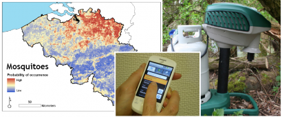
Figure 1: Mapping Mosquitoes in Belgium

ESA has enabled three companies to join forces in developing VECMAP, who are now working closely with  a representative selection of potential users, i.e. public health, industrial and academic entities. These involved users have been coordinated by The Dutch National Institute for Public Health and the Environment (RIVM).

VECMAP is a system and service that addresses the problem by integrating the entire process of producing risk maps into a single package that can be used by a wide range of practitioners.

"It literally is a one-stop-shop for vector mapping", says Dr Marieta Braks, a medical entomologist at RIVM.

VECMAP combines inputs from field work and Earth observation satellites such as vegetation, land temperature, moisture and water bodies. The field measurements are entered into a palm-to-web terminal or smart phone, which pinpoints them using satellite navigation. Then they are transferred to a central database. In this way, the field work can be done effectively and independently.

While VECMAP is tailored for mosquito mapping, it can be expanded to other vectors of disease targets that are largely under influence of environmental and climatic factors such as ticks, biting midges as well as wide range of animal and even the human diseases they transmit.

The consortium is led by Avia-GIS (BE), a company specialising in spatial risk management, and includes ERGO (GB), MEDES (FR) as developing partners; VITO (BE) and EARS (NL) which provide remote sensing imagery; and RIVM which represents the user community.

Teaser paragraph

ESA is helping to take the bite out of mosquitoes and their deadly diseases by tracking their distribution and habitat via satellite-based observations, navigation and mobile communications. The VECMAP initiative is testing the accurate mapping of mosquitoes in Europe, in particular...

IAP Call for User Ideas on the Alpine Region

Alpine Region - Call for User Ideas

The Integrated Applications Promotion (IAP) programme of the European Space Agency (ESA)  is inviting public and commercial organisations to propose ideas and suggestions for new services in the Alpine area. The aim is to generate ideas leading to new services that will improve business performance and operations, and help enforce new regulatory standards (for instance on environmental protection).


The ideas will be used to help define and consolidate requirements for user-driven services supported through the IAP.

Themes that it is intended to cover in this Call for User Ideas include (but are not restricted to):

  • Transport (public and private).
  • Tourism (e.g. search and rescue, telemedicine, safety).
  • Energy (e.g. hydropower, wind energy, solar energy).
  • Environmental Monitoring (e.g. pollution, natural hazards, biodiversity protection).
  • Any other promising topic.

The ideas submitted will be used to help define and consolidate requirements of IAP projects which are planned to start in 2012.

Full details of the Call and on how to submit your ideas can be found on the IAP portal at: /opportunities/iap/alpine-call-for-user-ideas.

Your ideas and suggestions should reach us by 22nd May 2011.

Teaser paragraph

IAP is inviting public and commercial end-user organisations to propose ideas and suggestions for new services in the Alpine region, leading to new services that will improve business performance and operations, and help enforce new regulatory standards.