Objectives of the service
Climate change impacts coastal areas through the rise of sea level amplifying the impact of extreme natural events such as hurricanes and coastal storms. Sea level rise induces shoreline erosion, coastal flooding, water salinization and more, threatening the livelihoods, population growth, urbanization, and natural ecosystems. It drives thus significant economic losses and affects the built-up areas behind the coastline.
Thanks to the latest advanced research and satellite observations, CORISCLIM tool reports on future climate-related coastal risks wherever, until 2100, along several scenarios to make decision ahead of time (e.g. to mitigate impacts, to update plans, to launch additional in-depth studies, to strengthen local capacities and build coastal resilience, and more).
Users and their needs
CORISCLIM tool is fitted to the use of:
-
Coastal authorities protecting the coastal communities, lives and property.
-
Coastal engineering firms & consultancies and companies providing solution to manage coastal zones and their risks.
-
Development banks or private investors funding climate resilience actions.
-
Climate Insurance firms evaluating future impacts on their clients’ assets.
-
Environmental associations and organizations (NGOs) supporting climate change awareness and actions in favour of climate change.
CORISCLIM answers the needs to:
-
Identify coastal areas potentially exposed to future coastal flood hazards due to mean sea level rise and extreme events;
-
Prioritize and decide where to deploy local actions (in-depth risk impact studies, engineering expertise, investments, financial support, insurance solutions, urban planning, etc);
-
Communicate and raise awareness to improve collaboration with practitioners and other stakeholders, to support business promotion activities.
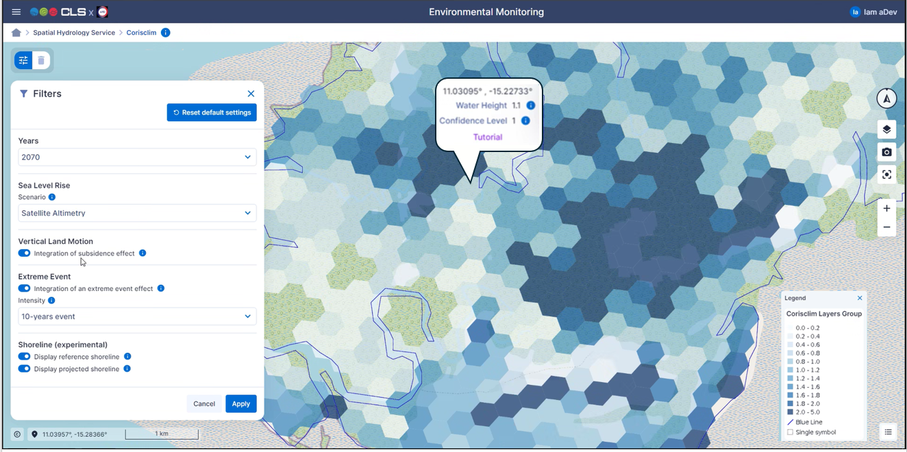
Service/ system concept
The online visualisation platform provides worldwide maps of future coastal hazards and allows to play along multiple scenarios.
-
Prognostics of Sea Level Rise per decade, 2030, 2040 2050, 2060, 2070, 2080, 2090 and 2100,
-
Resolution enhanced to 300m.
-
Visualization and access to products, with multi return periods of extreme events, (5, 10, 20, 50 or 100 years), waves runup effect, subsidence, erosion impacts.
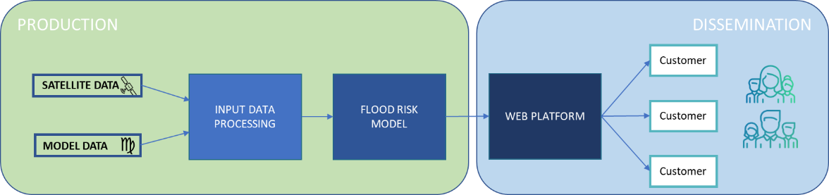
The system and service architecture is schematised below:
Space Added Value
CORISCLIM combines the use of 4 satellite systems that provide a unique opportunity to survey worldwide coasts and oceans:
-
Radar altimetry: for the dynamics of the oceans (change in sea level, waves, storm surges, tides)
-
Optical imagery: for the coastal erosion
-
Radar imagery: for the terrestrial digital elevation model
-
Synthetic Aperture Radar: for the land subsidence
Current Status
The design & development was conducted from February 2023 to April 2024, which will be followed by a pilot-demonstration of the service till October 2024.
The pilot-demonstration service is accessible free of charge upon request. If you are interested to be a pilot user, please contact us.
Prime Contractor(s)
Subcontractor(s)