
Objectives of the service
Data4Water addresses the multifaceted water management challenges in the Godavari River basin, a pivotal area designated as a Water Resilience Coalition priority. Farmers face uncertainties in irrigation, hydropower companies navigate river discharge fluctuations, and agrifood businesses seek reliable water sources. Local authorities manage water resources amid seasonal variations and climate change impacts.
Data4Water aims to enhance water resilience by providing accurate river discharge forecasts through the services provided by BWI. Tailored solutions address specific challenges faced by users, such as mitigating water scarcity risks, managing low water levels, and optimizing pumping practices. By leveraging Earth Observation data, in-situ measurements, and advanced machine learning algorithms, the service ensures precise insights into water-related dynamics. At BWI, integrating diverse data sources, coupled with advanced hydrological modeling and machine learning techniques, strengthens our services providing real-time data and forecasts for informed decision-making to address climate-induced water challenges.
The project strategically engages in Customer Identification, Value Proposition Definition, Technical and Commercial viability Assessment guiding the project towards the development of a proof of concept and the preparation for service implementation through continuous user engagement. By understanding user challenges and integrating advanced technologies, Data4Water aims to be more than a feasibility study. It represents a commitment to transforming water management in the Godavari basin through technology, collaboration, and sustainability.
Users and their needs
In India, our targeted users span vital sectors, including Agriculture and Farming, Aquaculture and Food Processing, and Water Treatment. Champion users within these domains have distinct needs, such as optimal irrigation practices, guidance on pond filling times, and improved wastewater treatment technology. The challenges faced involve mitigating the impact of river discharge fluctuations, ensuring compliance with industry standards, and adapting to changing hydrological conditions. The primary use case revolves around optimizing water availability for agriculture, offering a decision support system for optimal pumping times to prevent reaching critically low water levels. Additionally, a proactive use case arises from discussions with CEO Water Mandate, focusing on river water replenishment during low water conditions. These tailored solutions aim to positively impact water quality by lowering pollutant concentrations when preventing water from reaching critically low levels. Additionally, they seek to safeguard biodiversity and contribute to the resilience of the water-stressed Godavari River basin, addressing the specific needs and challenges of our identified user communities.
Service/ system concept
Data4Water Capability and User Information:
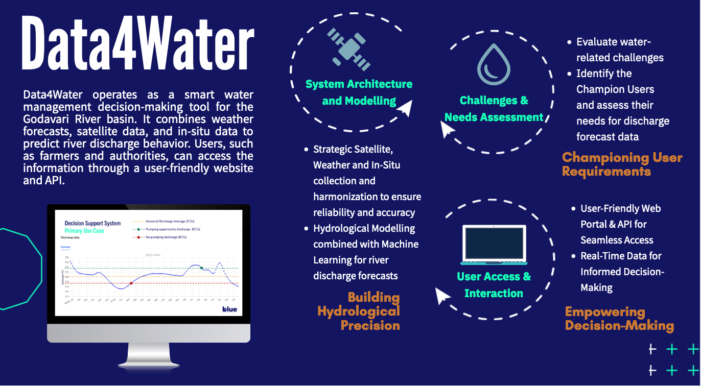
Data4Water delivers accurate river discharge estimates and forecasts over the Godavari River basin, empowering users with crucial insights for decision-making. Key features include:
-
Optimal Pumping and Replenishment Times: Users can identify the optimum time for pumping and releasing water, minimizing the risk of low water levels, maintaining pollutant concentrations, and positively impacting water quality.
-
Spatial and Temporal Resolutions: The system provides river flow estimates at user-defined points with adapted spatial resolutions, aligning with the frequency of weather forecast updates adapted for hydrological applications.
-
Data Consistency: Ensures reliable data products by harmonizing information from various sources, weather data, and historical river discharge, enhancing the overall accuracy.
-
Web Portal and API Accessibility: Users can access data through the system's user-friendly web portal and API, facilitating the visualization, access, and download of river discharge data. This system offers an intuitive interface for interaction, advanced functions, and facilitates ease of use and integration with external systems.
System Operation in Simple Terms:
Data4Water operates as a smart water management decision-making tool for the Godavari River basin. It combines weather forecasts, satellite data, and in-situ data to predict river discharge behavior. Users, such as farmers and authorities, access the information through a user-friendly website or even more “sophisticated” information systems.
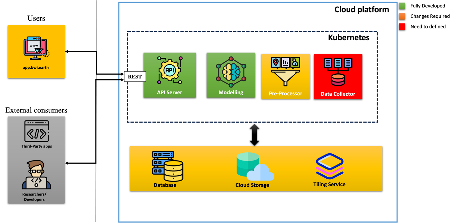
System Architecture Overview:
-
Data Foundation: Utilizing Amazon S3, the Data Foundation efficiently manages raw data in a cloud-based Data Lake, while Mapbox's Tiling Service organizes georeferenced data. A structured database (PostGIS, PostgreSQL) ensures consistency and efficient access.
-
Model: Data Collectors periodically gather external data using Python and Kubernetes, Pre-processors transform raw inputs into catchment-specific data, and Modelling Services, powered by neural networks, estimate river discharges.
-
Interface: FastAPI-driven API Server exposes data with modularity, and Clients, employing web components and Vue, provide intuitive user interaction, facilitating data visualization and access.
Space Added Value
The system relies on essential space assets such as SRTM, Copernicus, ASTER, and EUMETSAT data to achieve its goals. Leveraging space assets provides unparalleled advantages compared to traditional methods employed by potential competitors. Satellite-derived inputs, including DEM and numerical weather forecasts, offer a comprehensive and real-time understanding of the hydrological system. This access to dynamic and high-resolution data enables accurate modelling and forecasting of river behaviour, enhancing the precision of discharge estimates. The interconnectedness of river basins demands a holistic perspective, which space assets uniquely provide, ensuring a thorough understanding of complex hydrological dynamics. The competitive edge lies in the system's ability to harness the power of space data, enabling more informed and timely decision-making for water practices. This integration of space assets not only enhances accuracy and reliability but also offers a cost-effective and scalable solution, setting it apart from potential competitors relying on conventional approaches.
Current Status
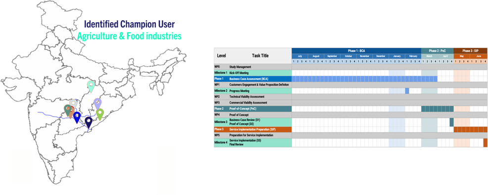
Our journey, beginning in July 2023, progressed with a productive kick-off meeting in October 2023, leading us into the business assessment case. By December 2023, we engaged with locals in the Godavari Basin, identifying agricultural and agri-food sectors as our Champion Users.
Currently, we are deeply immersed in the technical and commercial viability assessment, crucial groundwork for the upcoming Proof of Concept (PoC). We're defining technical specifications, crafting the PoC system design, and conducting a rigorous inventory of data sources, ensuring accuracy and reliability.
Simultaneously, our comprehensive commercial viability assessment involves analyzing key stakeholders, actively engaging in workshops, and seeking valuable feedback. This synergy positions us for successful integration into the broader landscape.
Looking ahead, in March 2024, the PoC phase will unfold, focusing on data aggregation infrastructure, data harmonization, storage layer setup, and user-friendly query interface development. Concurrently, webinar and workshop are planned to deepen user engagement and tailor the service based on their needs. The Service Implementation Preparation phase, starting in May 2024, will further consolidate our efforts, including historical data collection, ongoing data collection mechanisms, implementing a tailored processing layer, and ensuring user adoption through capacity building.